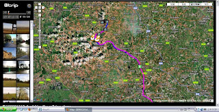
Satellite technology reveals how the network of city streets is being pushed to the edge of capacity. Watch the GPS traces of 380 London taxis over the course of a single day.
There are other videos to show what happend on above of Britain every day.People have different view and experience to see the earth through GPS .
GPS Drawing : combines art, travelling (walking, flying and driving) and technology and is a method of drawing that uses GPS to create large-scale artwork.(from Wikipedia)
The largest virtual image in the world: Artist Erik Nordenankar had an interesting idea for a self portrait. Well, the largest virtual image the world has ever seen. The GPS tracking device was put into a briefcase and sent away with the DHL transportation company which flew it around the world using travel instructions given to them.
There's nothing mystical or complicated about a sextant. All it is is a device that measures the angle between two objects.
The sextant makes use of two mirrors. With this sextant, one of the mirrors ( mirror A in the diagram) is half-silvered, which allows some light to pass through. In navigating, you look at the horizon through this mirror.
The other mirror (mirror B in the diagram) is attached to a movable arm. Light from an object, let's say the sun, reflects off this mirror. The arm can be moved to a position where the sun's reflection off the mirror also reflects off mirror A and through the eyepiece. What you see when this happens is one object (the sun) superimposed on the other (the horizon). The angle between the two objects is then read off the scale.
What makes a sextant so useful in navigation is its accuracy. It can measure an angle with precision to the nearest ten seconds. (A degree is divided into 60 minutes; a minute is divided into 60 seconds.)
This map is actually the Hereford Mappa Mundi. Produced around A.D. 1300, it is the oldest surviving medieval map from England and "the largest, most detailed and most perfectly preserved medieval map in the world" (Peter Whitfield, The Image of the World: 20 Centuries of World Maps, San Francisco: Pomegranate Artbooks, 1994, p. 20).
While we draw, Hands push the pressure to the pen in order to touch the papers. Touching is the bridging of architecture and the environment. For instance, using ultrasound technology scans the inside of human body that can reveal the organs beneath our skin. Digital technologies are allowing us to “touch” different space that are both inside and outside us and close to us and far away from us.
The detail of environment cannot be seen by our eyes but by touch of our hand through drawings.
I choose three different conditions of environments: cliff, swamp, and forest to experiment the concept.
First of three drawings used bird’s view to draw three sites, in addition, putting nine characteristics which I searched and shown on the blog into three sites in order to relate and communicate with environments.
Second, developing the object and at the same time and researching the technological side of the drawings, the instrument for exposing the unseen. For example, the artists used the camera Lucida to project the object on the paper to help them drawing. Taking the instrument into three environments and using different position to measure the sites. Furthermore, the device bases on three different sites to project the image on the papers in order to draw the journey plan. According to researching of the artists using camera Lucida, the device object is my drawing instrument and it constructed my drawing. Following the journey plan which is the process of drawing develop three maps, maps survey the instrument of the route which conceal and shift from the shadow. On the other hand, my drawing constructs the instrument
According to the maps, I begin to look through from the new scope to the real sites: cliff, swamp, and forest to observe. Then developing three models observe and explore the environments and leaving the trace on the papers. These three models become the observatories, furthermore, observing drawing of drawing.
This personal blog is to guide and upload the research, and further to clarify concepts used in this project. This research focus on the interaction between light and shadow, It presents how the observer communicates with environment is by the experience of the journey.
This project is about a peculiar journey in which the crucial aim is not necessarily to arrive the final destination but to record and describe the experiences of journey by the observer. In other words, the most relevant aspect of this journey is the information being “experienced” by observer before reaching the arrival per se, in Stone Circle, a historical site located in Oxfordshire(UK).
The main interest of this work is the interaction between people and environment, and how people perceive the world where they live. People can smell, see, touch, and listen, when they live in certain environment. The interesting issues are: what other forms of interaction with the environment would remain? What kind of conversation would exist between observers and objects?
The journey made by images focuses on the shadow of objects and the image of a place that is used, touched, walked, and seen. The series of photographs are arranged according to time-and-space intervals. The photographs are the trace, the footprints, and a specific interpretation of parts of the journey.